Microsoft ends support for Internet Explorer on June 16, 2022.
We recommend using one of the browsers listed below.
- Microsoft Edge(Latest version)
- Mozilla Firefox(Latest version)
- Google Chrome(Latest version)
- Apple Safari(Latest version)
Please contact your browser provider for download and installation instructions.


October 2, 2023
NTT Corporation
World's first millimeter-wave RFID tag to improve drone navigation accuracy
Aerial sensor network that continues to operate even in poor visibility conditions such as night, fog, and rain
Tokyo - Oct. 2, 2023 - NTT Corporation (NTT), in collaboration with The University of Tokyo, has developed a millimeter-wave RFID tag [1] that functions as a sign conveying information about the surrounding environment. By using RFID tags that can be read by millimeter wave [2], which are not affected by weather, accurate drone navigation can be achieved even in poor visibility conditions due to darkness or inclement weather (Figure 1). Using this technology, we will create a flexible society by building a sensor network that will continue to measure the environment from the air under all-day and all-weather conditions, even in unexplored areas where it would have been difficult to grasp information such as sea areas and disaster-stricken areas in the future.
This research will be presented on ACM MobiCom 2023, one of the challenging international conferences on IoT and ubiquitous computing, held from October 2 to 6, 2023.
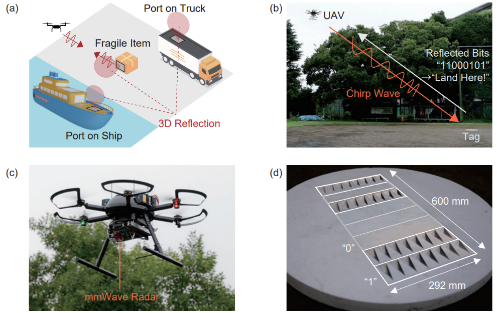 Figure 1 Overview of the technology. (a) Navigation that enables environmental measurement and transport of goods in combination with ships and trucks. (b) The drone guidance and tag reading method. (c) A drone equipped with a millimeter wave radar which is an RFID reader. (d)
The power-free RFID tag developed in this study has a wide reading range by a corner reflector structure.
1. Background
As the effects of climate change on global warming intensifies, it is urgent to create a society that is resilient to disasters. As part of this effort, it is essential to utilize next-generation air mobility, which is represented by drones. The revised Aviation Law, which came into effect in December 2022, has made it possible for drones to fly unmanned on aircraft remotely on inhibited area, making them useful for a variety of tasks, from environmental measurement to logistics. As a result, the use of drones is required both day and night and in various weather, and it is expected that they will contribute to disaster relief activities and to improving weather prediction accuracy through global environmental observation over a wide range of areas, including the ocean.
However, due to the heavy reliance on camera-based image recognition technology in unmanned drone flights, there has been a problem that flight performance is significantly reduced at night, in fog, rain, and other conditions where image recognition is difficult. Therefore, even under these conditions, new navigation technologies are needed to enable drones to properly understand their surroundings and perform advanced flights such as automatic landing and transportation of goods.
2. Results
We have developed a battery-less RFID tag that can read location and information over a wide area from the air using a small millimeter-wave radar that can be mounted on a drone. By using the tag as a sign that conveys information about the surrounding environment, allowing the drone to navigate safely even in poor visibility conditions. Various methods for drone navigation have been proposed in the past, but this technology is superior in that it can function under poor visibility and can be used in places where power cannot be installed. This enables all-weather drones to operate autonomously in unexplored areas where power supply is difficult to install, contributing to disaster response and improved weather prediction.
In addition, we have established a new tag structure design and signal processing method to solve the problems of narrow reading range and poor reading performance caused by surrounding structures, which were problems faced by conventional millimeter-wave RFID technology.
(i): Tag structural design: Corner reflector chipless RFID that can be read from a wide area in the air
In conventional RFID, the radio wave reflection range is narrow due to the use of a planar antenna, and the range that can be read from the air is limited. Therefore, we developed a new tag design method using a corner reflector with three-dimensional reflectivity (Figure 2). Specifically, we established a design method for bit patterns and readable distances (Figure 2-b) by changing the shape of the corner reflector structure (Figure 2-a) and arranging them like bar codes. The experiment showed that it can be read from a distance of more than 10 m with an elevation angle of more than 30 degrees and an azimuth angle of more than 20 degrees, and that the three-dimensional readable angle is more than 7.8 times the conventional value. (Figure 3)
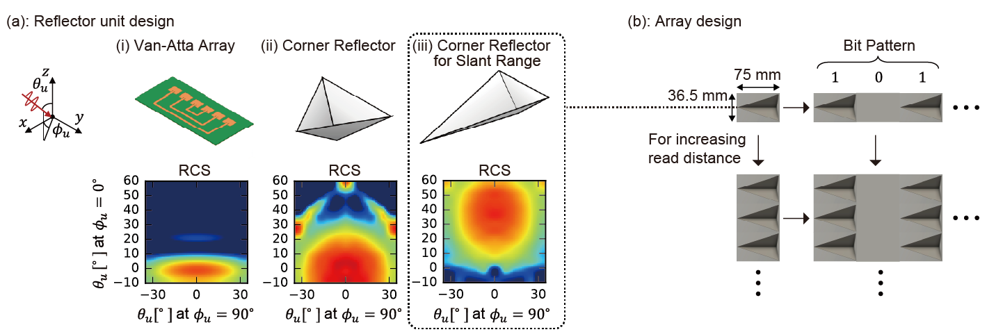 Figure 2 Overview of the RFID tag. (a) A corner reflector with an improved shape was adopted as a scatterer constituting the tag so that it reflects strongly in three dimensions. (b) Overview of corner reflector placement techniques for designing stored bits and read distances.
![Figure 3 Readable range verified by the experiment. (a) The evaluated coordinate system. (b) Signal strength when the angle with the tag is varied at a reading distance of 10 m. Comparison with the conventional method (Van Atta Array) [3] is shown. (c) Changes in signal strength and reading rate at different locations. Even at 10 m from the tag, a reading success rate of 90% or more is achieved in a range of 30 degrees or more of elevation angle and 20 degrees or more of azimuth angle.](img/231002ac.png) Figure 3 Readable range verified by the experiment. (a) The evaluated coordinate system. (b) Signal strength when the angle with the tag is varied at a reading distance of 10 m. Comparison with the conventional method (Van Atta Array) [3] is shown. (c) Changes in signal strength and reading rate at different locations. Even at 10 m from the tag, a reading success rate of 90% or more is achieved in a range of 30 degrees or more of elevation angle and 20 degrees or more of azimuth angle.
Figure 3 Readable range verified by the experiment. (a) The evaluated coordinate system. (b) Signal strength when the angle with the tag is varied at a reading distance of 10 m. Comparison with the conventional method (Van Atta Array) [3] is shown. (c) Changes in signal strength and reading rate at different locations. Even at 10 m from the tag, a reading success rate of 90% or more is achieved in a range of 30 degrees or more of elevation angle and 20 degrees or more of azimuth angle.
(ii): Signal processing: eigenvalue analysis and clustering for highly accurate tag reading in noisy environments
In conventional position estimation using FFT [4] in millimeter-wave radar signal processing, the spatial resolution is fixed, and the bit pattern reading success rate is low. Therefore, we introduced a spatial-reflection intensity estimation method that does not fix the spatial resolution using eigenvalue analysis to improve the reading success rate. We also developed a signal processing method that can automatically detect the position of a tag even in a noisy environment by clustering a point cloud containing the obtained spatial-reflection intensity information. As a result, it was confirmed that the tag can be detected and read with high accuracy even in situations surrounded by obstacles such as walls, cars, and stairs. (Figure 4)
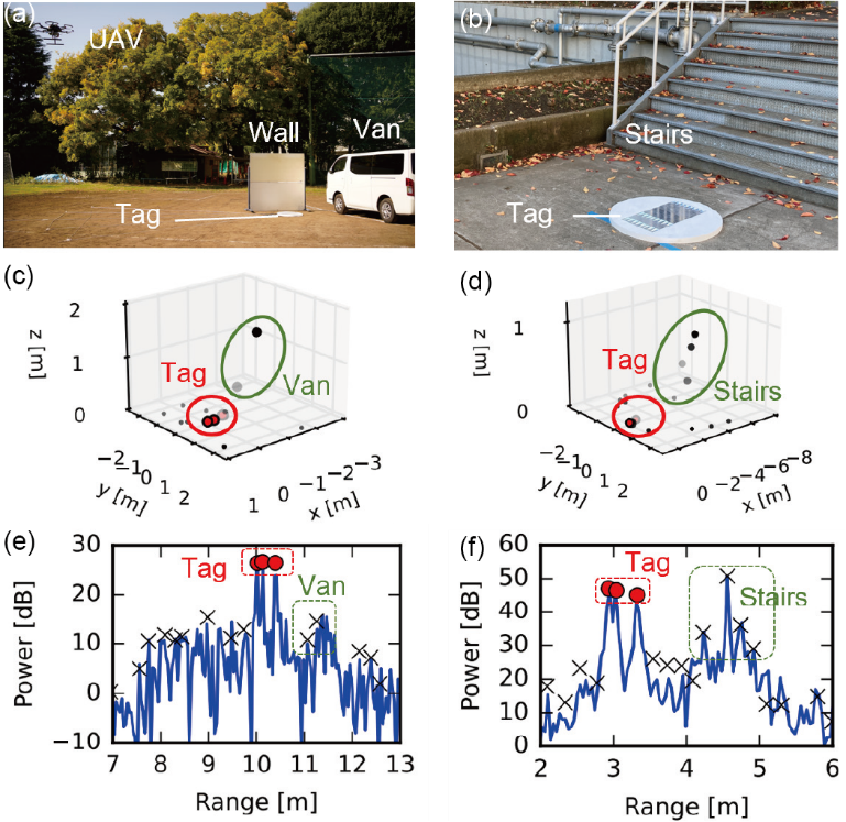 Figure 4 Validation results of the tag detection method in an environment with many unwanted reflections due to obstacles. Tags were placed near cars, walls, and stairs and measured. The developed tag has a pattern characteristic of the placement and strength of the reflector, indicating that it can detect even a large number of obstacles.
3. Role of each institution
- NTT: Development of signal processing method for millimeter wave radar, and an automatic tag detection method using spatial position estimation using eigenvalue analysis and point cloud clustering.
- The University of Tokyo: Development of RFID tags. Development of a design method for the shape and arrangement of corner reflectors.
4. Outlook
The guidance technology of millimeter-wave RFID tags, enables autonomous operation of drones in harsh environments such as darkness and bad weather, and promotes disaster response and advanced ocean observation. We aim to collaborate with partners in a wide range of fields, including logistics and medical care.
Ultimately, we will contribute to the realization of a resilient society by implementing systems optimized from hardware to software and strengthening the 4D digital infrastructure to grasp information in unexplored areas through an innovative empty sensor network consisting of not only drones but also a variety of IoT sensors.
Research introduction video
Presenter
NTT Space Environment and Energy Laboratories
Tatsuya Iizuka (Research Engineer)
Naoko Kosaka (Senior Research Engineer)
Toru Nakamura (Senior Research Engineer at the time of writing)
Masaki Hisada (Senior Research Engineer, Supervisor)
Graduate School of Engineering, The University of Tokyo
Takuya Sasatani (Assistant Professor)
Kawahara Yoshihiro (Professor)
Thesis Information
[Proceedings] The 29th Annual International Conference On Mobile Computing And Networking (MobiCom 2023).
[Title] MilliSign: mmWave-Based Passive Signs for Guiding UAVs in Poor Visibility Conditions.
Authors: Tatsuya Iizuka, Takuya Sasatani, Toru Nakamura, Naoko Kosaka, Masaki Hisada, and Yoshihiro Kawahara.
【DOI】 10.1145/3570361.3613264
<Glossary>
[1]RFID tag
Radio frequency identification refers to a system that can read stored information by radio waves.
[2]Millimeter Wave
Radio waves with a frequency of 30 GHz -300 G. It has high directivity and transparency, and is also used as an inter-vehicle distance sensor mounted on a vehicle.
[3]Van-Atta Array
One of the antenna arrays arrangement method for realizing reflection to a wide range.
[4]FFT
It refers to the Fast Fourier Transform, which is often used as a technique for fast frequency analysis of time-series signals.
About NTT
NTT contributes to a sustainable society through the power of innovation. We are a leading global technology company providing services to consumers and business as a mobile operator, infrastructure, networks, applications, and consulting provider. Our offerings include digital business consulting, managed application services, workplace and cloud solutions, data center and edge computing, all supported by our deep global industry expertise. We are over $95B in revenue and 330,000 employees, with $3.6B in annual R&D investments. Our operations span across 80+ countries and regions, allowing us to serve clients in over 190 of them. We serve over 75% of Fortune Global 100 companies, thousands of other enterprise and government clients and millions of consumers.
Media contacts
NTT Corporation
Public Relation, Information Network Laboratory Group
nttrd-pr@ml.ntt.com
Information is current as of the date of issue of the individual press release.
Please be advised that information may be outdated after that point.


NTT STORY
WEB media that thinks about the future with NTT