Microsoft ends support for Internet Explorer on June 16, 2022.
We recommend using one of the browsers listed below.
- Microsoft Edge(Latest version)
- Mozilla Firefox(Latest version)
- Google Chrome(Latest version)
- Apple Safari(Latest version)
Please contact your browser provider for download and installation instructions.


May 12, 2025
NTT Corporation
Established a Damage Prediction Technology to Visualize Road Disruption Risk During Heavy Rainfall
Quick and simple nationwide road assessment without on-site surveys
News Highlights:
- By applying our already-established damage prediction technology for communication infrastructure during disasters, we have developed a new method for predicting road damage caused by heavy rainfall.
- This technology enables road damage prediction using only publicly available information, based on a machine learning model built from inspection data accumulated by NTT during past disaster events. It allows for rapid estimation of damage risk across Japan according to rainfall levels, and has been confirmed to perform as well as or better than conventional hazard maps1.
- Going forward, we aim to assess the potential of this technology through trials on actual roads and explore its application in pre-disaster planning. Through this, we strive to contribute to disaster prevention, mitigation, and faster recovery across the broader social infrastructure.
TOKYO - May 12, 2025 - NTT Corporation (Headquarters: Chiyoda, Tokyo; President and CEO: Akira Shimada; hereinafter "NTT") has developed a road damage prediction technology for heavy rainfall disasters by adapting its existing method for forecasting damage to communication infrastructure during disasters. This technology enables the estimation of disaster risk using only publicly available data—without the need for on-site surveys, detailed infrastructure information, or historical road damage records. It also allows for rapid prediction in areas where hazard maps do not exist. Furthermore, performance evaluations have confirmed that the accuracy of this technology exceeds that of conventional hazard maps.
Looking ahead, this technology can support more effective disaster preparedness by enabling authorities to pre-plan evacuation routes and logistics or emergency vehicle routes based on predicted road damage risks. In doing so, it contributes to strengthening regional resilience through more efficient disaster risk reduction and evacuation planning.
This technology will be showcased at "Tsukuba Forum 2025"2, to be held from May 15 (Thu) to 16 (Fri), 2025 (JST).
 Figure 1 Overview
Background
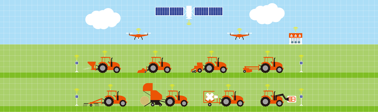
In recent years, heavy rainfall disasters have intensified, and there have been increasing cases of tilted utility poles and severed communication cables caused by landslides and embankment collapses during such events. To enable proactive responses to these disasters, NTT has developed a technology that predicts utility pole damage using publicly available data and past inspection records. This technology makes it possible to simulate and predict utility pole damage across Japan without fieldwork, using only desktop analysis.3
Meanwhile, heavy rainfall disasters not only damage communication infrastructure but can also lead to landslides and embankment failures on roads, causing entire communities to become isolated. While it is important to assess such risks in advance and take preventive measures, creating hazard maps requires on-site surveys and trained engineers, making it difficult to forecast damage across all roads before disasters occur.
Technology Highlights
Building on this background, NTT has developed a foundational technology for predicting road damage by adapting its previously established utility pole damage prediction model. As shown in Figure 2, virtual utility poles are placed along the roads to be analyzed, and the damage prediction model is applied using only the road's location data. This makes it possible to quantitatively assess road damage risk on a grid-by-grid basis (10-meter resolution).
Since many utility pole failures are caused by road collapses or falling trees due to landslides, this approach leverages the similarity in damage factors between poles and roads to enable accurate predictions.
- Nationwide predictions using only publicly available data
Because this method predicts damage to virtual utility poles using a model trained on utility pole damage data, it does not require detailed information such as road surface conditions, traffic volume, or engineering blueprints. This allows predictions to be made for any area across Japan.
Additionally, the utility pole damage prediction model itself uses only publicly available data—such as elevation, slope, and ground hardness—eliminating the need for in-depth geological surveys. - Fast prediction enables real-time estimation
This technology does not rely on time-consuming numerical simulations. By preparing basic data for the target area in advance using public datasets (e.g., elevation, slope, ground hardness), it can quickly estimate damage risk using forecasted rainfall levels, the latest weather predictions, or actual rainfall measurements.
As a result, it can be effectively used for estimating damage just before or immediately after heavy rainfall, supporting evacuation route planning and emergency response.
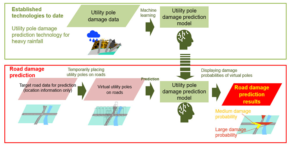 Figure 2 Overview of Road Damage Prediction
Overview of the Experiment
Using a prediction model trained on inspection data that recorded whether utility poles were damaged during a heavy rainfall event in July 2020, along with surrounding environmental data such as elevation, we predicted part of the road damage caused by the heavy rainfall in the Noto Peninsula in September 2024, and quantified the associated risk.
Approximately 122,000 virtual utility poles were placed along roads and surrounding areas within the target region. The model's predictions of damage to each pole were then compared with slope failure, debris flow, and sediment distribution data4. When using hazard maps for interpretation, the accuracy was 77%, correctly identifying approximately 94,000 poles. In contrast, our technology achieved a higher accuracy of 80%, correctly identifying approximately 98,000 poles, confirming the superior performance of this prediction model. Additionally, we confirmed that this technology was able to successfully predict damage in certain areas within the region that currently lack hazard map coverage but were nonetheless affected by the disaster.
Future Developments
We aim to build partnerships with private companies and local governments to conduct trial implementations of this technology for use in real evacuation planning and pre-disaster planning. At the same time, we will continue research and development to expand damage prediction not only for heavy rainfall but also for earthquakes, as well as to apply the technology to other types of infrastructure. By leveraging the data that NTT has accumulated over time, we strive to contribute to disaster prevention, damage mitigation, and rapid recovery of social infrastructure, ultimately working toward the realization of a more disaster-resilient society.
[Glossary]
1Hazard map
Refers to areas at risk of landslides (landslide warning zones and special landslide warning zones) as published on the hazard map portal site.
URL: https://disaportal.gsi.go.jp/![]()
2Tsukuba Forum 2025
URL: https://www.rd.ntt/e/as/tforum/![]()
3Press release "Building an AI to predict infrastructure damage from disasters"
URL: https://group.ntt/en/newsrelease/2024/04/25/240425a.html
4Slope failure, debris flow, and sediment distribution data
Based on aerial photographs taken by the Geospatial Information Authority of Japan on September 23 and 24, this dataset identifies areas of slope failure, debris flow extents, and sediment deposition believed to have resulted from the heavy rainfall starting on September 20, 2024.
URL: https://www.gsi.go.jp/BOUSAI/R6_noto_heavyrain.html![]()
About NTT
NTT contributes to a sustainable society through the power of innovation. We are a leading global technology company providing services to consumers and businesses as a mobile operator, infrastructure, networks, applications, and consulting provider. Our offerings include digital business consulting, managed application services, workplace and cloud solutions, data center and edge computing, all supported by our deep global industry expertise. We are over $92B in revenue and 330,000 employees, with $3.6B in annual R&D investments. Our operations span across 80+ countries and regions, allowing us to serve clients in over 190 of them. We serve over 75% of Fortune Global 100 companies, thousands of other enterprise and government clients and millions of consumers.
Media contact
NTT Information Network Laboratory Group
Public Relations
Inquiry form![]()
Information is current as of the date of issue of the individual press release.
Please be advised that information may be outdated after that point.


NTT STORY
WEB media that thinks about the future with NTT