Microsoft ends support for Internet Explorer on June 16, 2022.
We recommend using one of the browsers listed below.
- Microsoft Edge(Latest version)
- Mozilla Firefox(Latest version)
- Google Chrome(Latest version)
- Apple Safari(Latest version)
Please contact your browser provider for download and installation instructions.
NTT's Sustainability Efforts
Social impact of "flow of people data" generated from approximately 85 million samples
DOCOMO InsightMarketing, Inc. Area Marketing Department (At the time of interview)
Reiko Asano/Mina Kato


Viewing the "movement of people" helps to visualize "society and the economy"
It is no exaggeration to say that society is formed with the movement of people, like the daily commute to work or school, going shopping or engaging in leisure activities. The "flow of people" that indicates the movement of people--congested vacation destinations on holidays or COVID-19 resulting in a lack of people in business districts--is closely related to the economy and lifestyles.
"Society, the economy and the movement of people are all intertwined. "Mobile spatial statistics" provides a way to "visualize" the movement of people, and I think it will become an essential technology as the foundation of all efforts to support society." (comment from Mina Kato follows below )
DOCOMO InsightMarketing provides "mobile spatial statistics" that estimates populations based on operational data acquired by using the connectivity of NTT DOCOMO cell phones. Cell phones are carried by people almost all the time, wherever they go. Identifying the presence of cell phones within the area of a base station allows the movement of people around the country to be visualized in real-time.
"Analyzing data on the movement of people also means towns can be planned that are convenient to live in, by arranging the locations of schools and hospitals, or planning train and bus routes. It can also be used to analyze the travel plans that foreign tourists visiting Japan take as a way of promoting tourism, surveying trade areas before opening new stores, and planning and measuring the effects of advertisements. Mobile spatial statistics is a service that extend beyond industry sectors and can be used for a wide range of applications, from small and medium businesses to large corporations and government organizations." (comment from Reiko Asano follows below)

"Now is the time to help society" - releasing data free-of-charge during the COVID-19 pandemic
Mobile spatial statistics is a useful tool in a range of different scenarios, from urban planning to marketing. Ms. Asano and Ms. Kato explain that the underlying reasoning for this is "social contribution." The growing number of COVID-19 infections made members of the mobile spatial statistics team become even more aware.
"When the state of emergency was first declared in April 2020, countless people were restricted from going outside. Was there anything that we could do? When we looked into this, we came up with the idea of providing correct data to the citizens.
At the time, preventing infections required avoiding "clusters," and DOCOMO received inquiries from media outlets around the clock requesting the use of mobile spatial statistics for identifying areas of congestion in real-time. It was nearly impossible to respond to each and every inquiry we received. We also felt there was also the need for neutral information that was not subjected to the bias of any particular media outlet.
In response to these requests, efforts were made to make "mobile spatial statistics" accessible to everybody so that information could be viewed from anywhere. Population maps shown to visualize areas of congestion as heat maps were made available for free." (Asano)
Despite team members unable to work at the office due to COVID-19, the population maps were developed quickly over around a month.
"Speed was of the essence at the time. We pushed ahead with development while keeping speed in mind, but it was difficult to find a balance between finding the best way to create a service that is easy to use. Major areas around the country can be viewed with more detailed, but what bar do we use to decide on those areas, and how much data should we include?" (Kato)
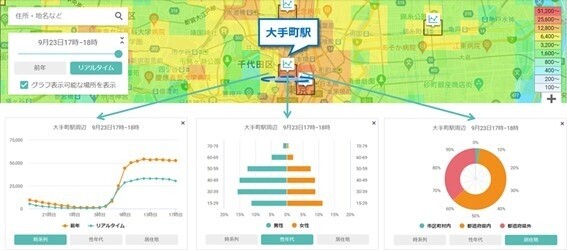 Population map provided by mobile spatial statistics. Population densities can be viewed for each time and area
In addition to visitors to the site, population maps released by mobile spatial statistics were quickly covered by various forms of media, and word spread quickly. Project members like Ms. Asano and Ms. Kato also received a lot of feedback.
"I started receiving notifications from friends who saw the service in media like the television or newspapers. Under this project, data that we had been supplying for a charge was released free-of-charge. The team quickly found common ground because "now is the time to help society," but I was so happy when client companies praised our work by saying "That's something only DOCOMO can do." (Asano)
Social contribution based on the technical team's vision leads to my own affirmation

Processing data of around 85 million people, developing products in the midst of the COVID-19 pandemic and other achievements of mobile spatial statistics are underpinned by the solid technical capabilities of NTT DOCOMO. These technical capabilities are being harnessed to contribute to society by delivering mobile spatial statistics that is evolving on a daily basis. This formed a source of motivation for Ms. Asano and Ms. Kato.
"To provide mobile spatial statistics as a service, we needed to strip the personal information of users, convert communication data to population numbers, and quickly process some 100 GB of data every day.
Making this possible was the extensive track record that NTT DOCOMO's research labs have with positive results. These efforts feature the devotion of so many researchers. While users might not notice anything during normal use, behind the scenes the service is built on the vision of many people and their commitment to contribute to society.
To ensure that this mobile spatial statistics service can be provided customers, our team also needed to put in our utmost effort. We also hope to provide a new sense of value to society by having players in various industries use mobile spatial statistics and combining it with customers' data or technologies." (Kato)
"Members involved in the project have always viewed mobile spatial statistics as a way of helping to resolve social issues. In this sense, it was only a natural response to provide society with something at the height of COVID-19. Members in charge of sales as well as technical development really do have a sense of pride in mobile spatial statistics.
Being involved in this work during COVID-19 personally gave me a feeling of confidence in my own work. I often tell my sons that they need to believe in themselves, and this is what I am actually feeling right now as I enjoy my work. In a way, this project has also added a spark to my own lifestyle." (Asano)
Sustainability
NTT STORY
WEB media that thinks about the future with NTT


